- Arctic sea ice hit its 2025 summer minimum without setting a record low on Sept. 10, despite a historically low winter maximum earlier in the year.
- Scientists say sea ice loss has slowed over the past 20 years due to natural variability in atmospheric and ocean systems, counterbalancing the impacts from human-caused climate change.
- However, researchers warn that this slowdown likely offers only a temporary reprieve, and that the continued escalation of global warming could cause rapid sea ice loss before 2050.
- The U.S. National Snow and Ice Data Center for the first time switched to using Japanese sea ice data after losing access to key U.S. military satellite data, which had allowed for a continuous Arctic sea ice record since 1979.
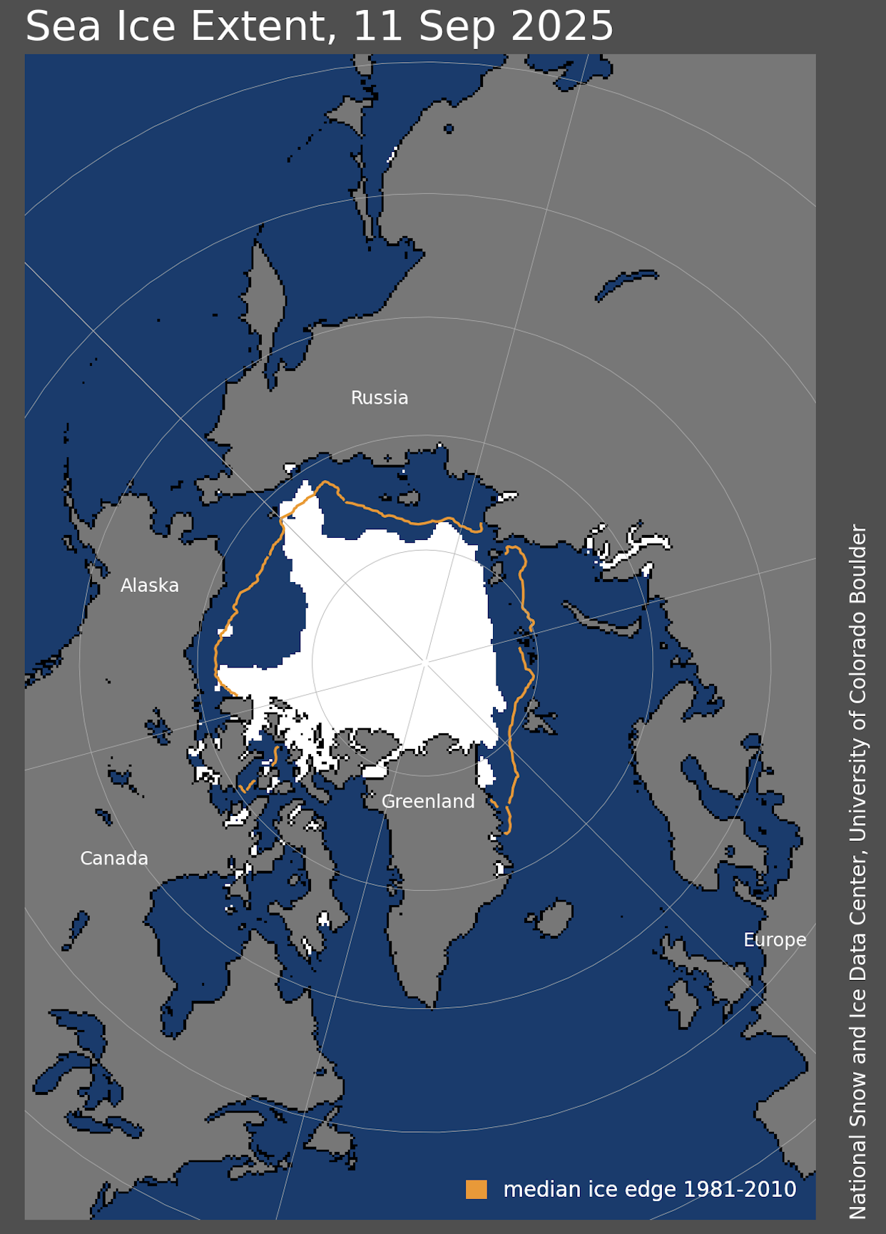
Sea ice floating atop the Arctic Ocean reached its minimum extent for 2025 on Sept. 10, covering 4.602 million square kilometers (1.78 million square miles) concluding this year’s summer melt-out. That’s far from a record low and represents a recovery, in some ways, from where things stood earlier this year.
At the winter maximum in March 2025, the Arctic ice was in bad shape. That’s the month in which sea ice, encouraged by freezing temperatures and 24-7 darkness, annually reaches its greatest extent. Ice cover in the region then barely topped 14.3 million square kilometers (5.5 million square miles) — the smallest extent at the winter maximum observed in the 47-year satellite record, and more than 1 million km2 (386,000 mi2) below the 1981 to 2010 average winter maximum.
Much of 2025 followed a similar downward sloping path; throughout June and into early August, Arctic sea ice cover was tracking close to, if not at, a record low for the time of year. But things swung around in the latter half of August, as ice melt stagnated.
“You get to August and the sun is setting in the Arctic, so things start to slow down,” said Walt Meier, a senior research scientist with the National Snow and Ice Data Center (NSIDC) in Colorado. “You need a lot of momentum to keep going, some kind of unusual winds or a big storm like we had in 2012,” the record low sea ice minimum year. “We haven’t really seen that this summer.”
Meier noted that this year’s minimum extent is nothing unusual when compared with recent years, and ranks as the 11th lowest annual Arctic ice extents since recordkeeping began in 1979.
A 20-year sea ice extent slowdown
The fact that Arctic sea ice extent has not once broken the minimum record set in summer 2012 can seem counterintuitive at first glance, especially when considering the hastening speed of climate change and record warm years over the last decade. But researchers say that failure to set a new record is to be expected and in line with modeling evidence published in August in the journal Geophysical Research Letters.
Following record-breaking Arctic sea ice minimums in 2007 and 2012, some polar scientists had projected that the Arctic polar region could begin seeing ice-free summers before 2020. After all, the north polar region has been warming roughly four times faster than the global average, and sea ice cover is strongly tied to global temperatures.
But that never happened.
“If you had just drawn a straight line, you’d have been pretty wrong,” said climate scientist Mark England, who led the study team while working at the University of Exeter in the U.K. “So that’s good news in terms of it’s less bad currently than one might have imagined.”
According to the recently published research, which analyzed several climate model simulations, natural variability in complex oceanic and atmospheric systems acted as a counterweight to accumulating heat over the past 20 years.
From 2005-24, sea ice loss was actually slowing down compared with previous decades, according to observed data sets, with no statistically significant decline seen in September sea ice area since 2005. Accordingly, scientists’ climate model simulations predicted a 20% chance of pauses in sea ice loss lasting two decades, despite rapidly increasing greenhouse gas emissions.
“There has been some sea ice loss, but it has been much slower than it was before,” England said. “I think two things can be true at once — we are near record lows, but [minimum extent] hasn’t decreased that much over the past 15 or 20 years. It hasn’t continued that rapid trend down that we saw around the early 2000s.”
Summer sea ice extent, however, is still at least 33% less than it was around the beginning of the satellite record nearly 50 years ago. The study found that the 20-year period stretching from 2005-24 saw the slowest rate of sea ice area loss since the late 1970s, according to European data sets, or the second-slowest in the NSIDC record.
Arctic sea ice loss overall has been roughly 4-5 times smaller than the peak period of Arctic ice loss from 1993 to 2012.
England theorized that ocean systems are largely responsible for the slowdown, as it has happened in every month of the calendar year. Atmospheric phenomena, he said, typically only affect some months of the year. In this case, the slowdown may have been tied to the Pacific decadal oscillation or Atlantic multidecadal variability.
While a smaller ice decline may sound like a rare bright spot, it doesn’t negate the fact that human-caused climate change has played a huge role in present-day Arctic ice loss. Notably, recent decades have also seen a plunge in Arctic multiyear ice and sea ice volume.
England said the team’s research suggests that if not for human emissions, the period from 2005-24 may have been a period of substantial sea ice growth, similar to what the world saw around the 1920s and 1940s. With rapid global heating, however, this meant only that the sea ice melted out more slowly.
Moreover, the slowdown can’t last forever. Natural variability has offered a temporary reprieve, England said, but the research team’s models showed that the pauses in September sea ice loss have only a one in four chance of persisting for another decade. Higher carbon emission scenarios presented even lower odds of sustaining a muted pace of future ice loss.
Concerningly, when the slowdown does end, the anomalously high amounts of sea ice remaining could more rapidly melt away. The loss of all or most of the white reflective summer sea ice would result in the dark-blue waters of the Arctic Ocean absorbing lots of solar radiation, quickening the pace of global warming.
Data deviations
This year’s minimum ice extent may be a far cry from the record-breaking 2012 low of less than 3.5 million km2 (1.4 million mi2), but for U.S. scientists, 2025 remains unprecedented.
It’s the first time in 38 years that scientists with the U.S. National Snow and Ice Data Center have had to rely on a Japanese satellite and instruments that measure ice cover to make their final call for September.
Earlier this year, scientists with the NSIDC — an information center affiliated with the U.S. National Oceanic and Atmospheric Administration and part of the University of Colorado Boulder — noticed holes in the data they were receiving from the U.S. Defense Meteorological Satellite Program (DMSP), which uses a passive microwave radiometer system known as SSMIS.
“We started to realize back in May when we were not getting complete data — some of the orbits would drop out so our maps were showing gaps,” explained NSIDC’s Meier.
When scientists inquired with the Department of Defense (DoD), they were told not all data were being downloaded and access to the data had been deprioritized. Soon after, the DoD said it would stop sharing DMSP data altogether, citing military cybersecurity risks in the old systems. (The satellites were also never intended to track sea ice, but rather to track wind speeds over oceans.) The DoD set a cutoff date of July 31, 2025.
Shock waves rippled through the scientific community as researchers scrambled to find workarounds to the patchy DoD data. NSIDC and Europe’s Copernicus Climate Change Service compile the two most notable global sea ice records, and both groups rely on the DoD data.
Sea ice data figure prominently into global climate models, as well as weather and forecasting models. “You need to know whether there is sea ice, because if there is ice, it’s a lot different than open water — there is a different heat flux, different temperatures, different moisture,” Meier explained.
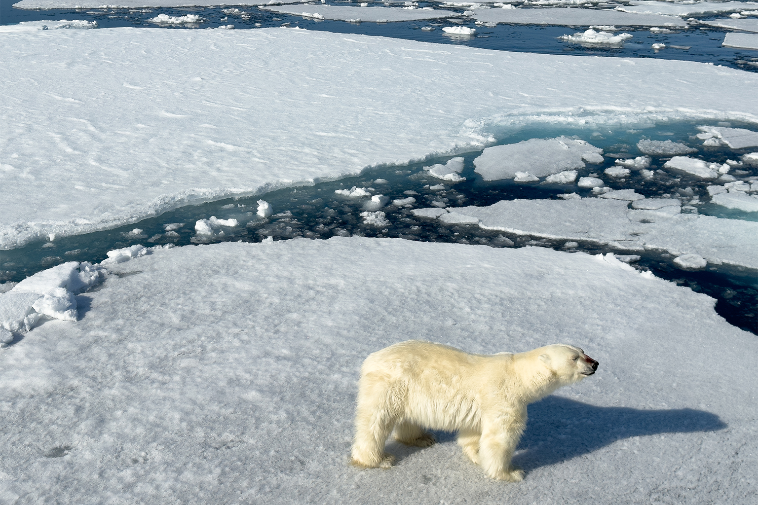
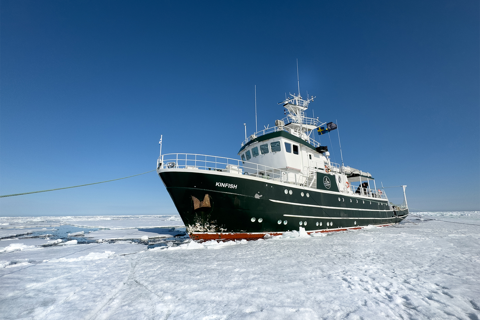
While most ocean-going ships don’t rely on DoD sea ice data sets for direct navigational support, some vessels do use the NSIDC’s data alongside operational ice charts for general trends and daily changes. Polar bear scientists, too, Meier said, use the data to know when bears might be coming in off the sea ice, or heading out.
Moreover, the DMSP data is used not only to track sea ice extent, but also to help monitor the paths and intensities of hurricanes.
Following pushback, the Department of Defense said they would extend data distribution with civil agencies and meteorologists until September 2026. A new DoD weather satellite launched last year is capable of collecting similar data, but its data is not yet public.
Meier said the NSIDC has already elected to switch over its data source to an instrument known as AMSR2 aboard a Japanese satellite launched in 2012. Typically, the transition would have been made over several months. “You do some careful adjustments, especially working with a different sensor. But we haven’t had that time. What we have done, I think, works pretty well.”
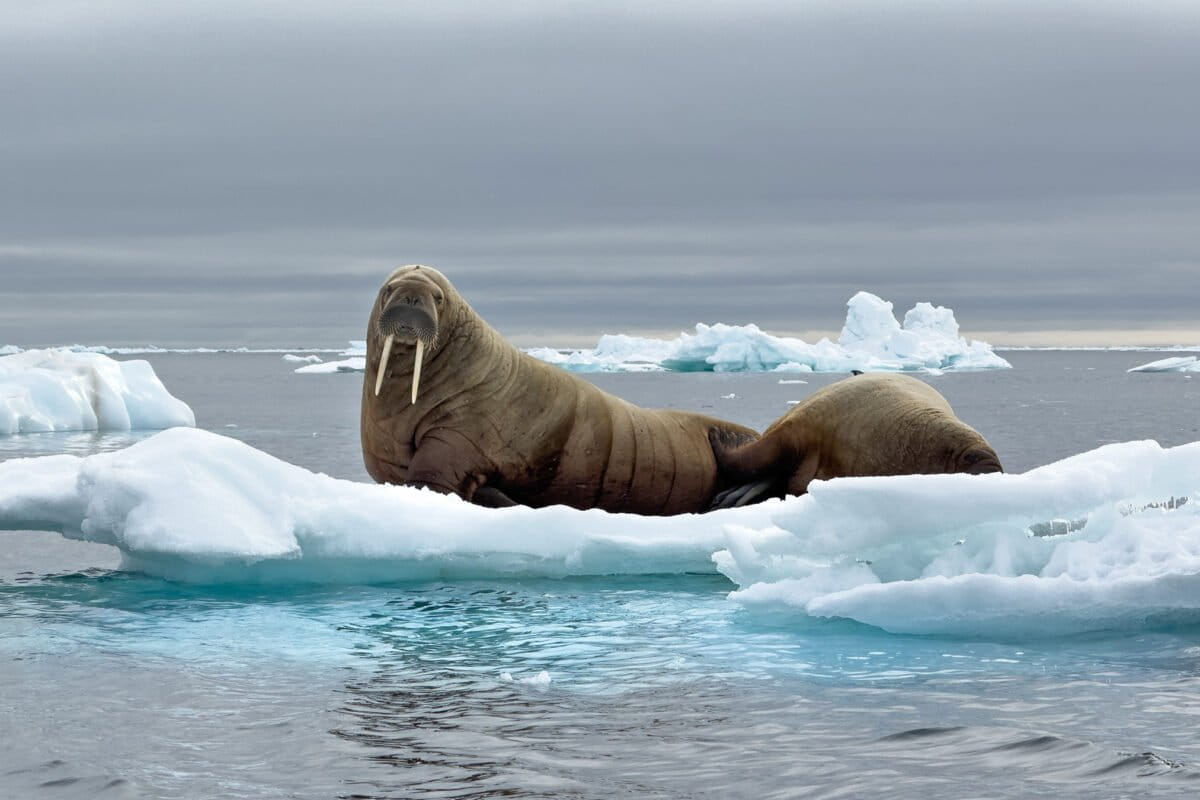
Banner image: Two walruses atop a small piece of floating Arctic sea ice. Image by Sharon Guynup/Mongabay.
Polar sea ice continues steep decline; but will a troubled world notice?
Citations:
England, M. R., Polvani, L. M., Screen, J., & Chan, A. C. (2025). Minimal Arctic sea ice loss in the last 20 years, consistent with internal climate variability. Geophysical Research Letters, 52(15), e2025GL116175. doi:10.1029/2025GL116175
FEEDBACK: Use this form to send a message to the author of this post. If you want to post a public comment, you can do that at the bottom of the page.