From the beginning of the Israeli response to Operation al-Aqsa Flood on October 7, 2023, it was clear that the Zionist state had launched a war deadlier and more destructive than all its previous wars. This was the result of the interaction between the most extremist government in the history of that state and the most serious attack launched by an armed Palestinian organization in the history of Palestinian resistance. Unfortunately, what I predicted in my first commentary on the events, just three days after the Hamas-led operation, has come true to the letter:
Operation al-Aqsa Flood has reunited an Israeli society that was suffering from a deep schism and a serious political crisis. It has empowered Benjamin Netanyahu and his colleagues on the far right of the Zionist movement to drag the Zionists of the opposite political side with them in preparation for a war that is increasingly and alarmingly taking on the hallmarks of a genocidal war. This begins with their imposition of a total blockade, including electricity, water, and food, on the entire Gaza Strip and its population of close to two and a half million. It is a flagrant and extremely serious violation of the laws of war, confirming that the Zionists are preparing to commit a crime against humanity of the highest caliber.
Since the establishment of the state of Israel, the Zionist right has dreamed of completing the 1948 Nakba with a new mass expulsion of Palestinians from the lands of Palestine between the river and the sea, including the Gaza Strip. There is no doubt that they now see what happened last Saturday as a shock that will allow them to drag the rest of Zionist society behind them in realizing their dream in the Gaza Strip first, while awaiting the opportunity to implement it in the West Bank.
The seriousness of what befell Israel last Saturday is likely to mitigate the deterrent effect of Hamas’s hostage-taking, unlike what occurred in previous rounds of confrontation between the movement and the Zionist state. It is very likely that this time, the latter will not be satisfied with anything less than the destruction of the Gaza Strip to an extent exceeding anything we have witnessed to date, in order to reoccupy it at the lowest possible human cost to Israel and cause the displacement of most of its population to Egyptian territory, all under the pretext of completely eradicating Hamas from it.
This did not require a unique power of prediction; it was plainly visible to anyone who wanted to see and was not blinded by ideology, emotions, or illusions. Three days later, on October 13, 2023, less than a week after the tragedy began, Raz Segal, a professor of Holocaust and genocide studies at Stockton University in the United States (and an Israeli citizen), published a bombshell article in the progressive American magazine Jewish Currents, commenting on what had started unfolding in Gaza under the title “A Textbook Case of Genocide.” Segal pointed to the stark reality of the proliferation of statements by Israeli officials that indicated an explicit intent for genocide, coupled with the indiscriminate killing of Gazan civilians and calls, as well as measures, aimed at their displacement.
Since the first days of Israel’s war on Gaza, the “war of narratives” has been raging feverishly, parallel to the horrific military onslaught. It took weeks, even months, before the debate shifted from the suitability of comparing Operation al-Aqsa Flood to the pogroms of Jews in European history, all the way to the Nazi Holocaust, to the suitability of applying the concept of “genocide” to what the state of Israel has been doing in the Gaza Strip.
A year after the invasion began, condemnations of what was happening in Gaza as genocide began to multiply, whether issued by law organizations, human rights organizations, or scholarly groups. These include, among others, charges issued by the International Criminal Court and the International Court of Justice, reports issued by Amnesty International, Human Rights Watch, the UN Special Rapporteur on the situation of human rights in the Palestinian territories occupied since 1967, and more recently, by two Israeli organizations: the Israeli Information Center for Human Rights in the Occupied Territories (known as B’Tselem) and Physicians for Human Rights.
The most recent resounding position in this regard is the resolution issued by the International Association of Genocide Scholars on August 31, which was supported by 86 percent of those who voted among its five hundred members. The recognition that what is happening in Gaza is genocide has become so sweeping that the debate has now shifted, from the accusation that the genocide label is tendentious to the accusation that the rejection of this label itself belongs to the category of genocide denial (which also includes Holocaust denial). This accusation was forcefully made by Daniel Blatman, an Israeli historian specializing in the history of the Holocaust and a professor at the Hebrew University of Jerusalem, in a Ha’aretzarticle on July 31 entitled “The Victim Identity Israel Built Over Generations Now Fuels Its Denial of Genocide in Gaza.”
One of the most deplorable examples of denial is an article published in the Jerusalem Post by Israeli lawyer Nitsana Darshan-Leitner, president of the Israel Law Center (Shurat HaDin), which defends the Zionist state before the International Criminal Court. The article, published on July 28, may have contributed to inciting Blatman to write his own. In it, the lawyer vociferously responds to Omer Bartov, also a professor of Holocaust and genocide studies, teaching at Brown University, who had published a July 15 New York Timesarticle entitled “I’m a Genocide Scholar. I Know It When I See It.”
The deplorable message in Darshan-Leitner’s article reaches its peak when she criticizes Bartov’s description of Israel’s actions as genocide, arguing that it “cheapens” the term and “erases the unique horror” of internationally recognized genocides, among which the author mentions what happened in Bosnia. The fact is that the Bosnian genocide, during the Bosnian War in the first half of the 1990s, killed approximately 30,000 people and displaced approximately one million non-Serbs out of a total of 2.7 million (i.e., 37 percent of the total).
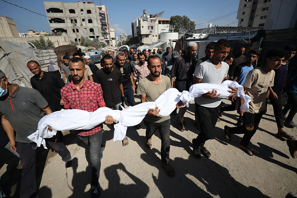
So what about what’s happening in Gaza, where the direct death toll has so far reached approximately 64,000 (not counting the unknown dead under the rubble and indirect deaths, which far outnumber direct ones) and the displacement of approximately two million out of a total 2.2 million population (i.e., more than 90 percent)? How can this horrific outcome “cheapen” the concept of genocide and “erase its unique horror” compared to what happened in Bosnia?
The truth, which is becoming increasingly difficult to deny, is that the ongoing genocide in Gaza, both in terms of its proportion of the total population and in terms of the degree of brutality of the perpetrators, has already gone down in history as one of the most horrific instances of genocide the world has seen since World War II. This genocide is the work of an industrialized state whose technological distinction, backed by the most powerful state on earth, has enabled it to distinguish itself in its barbarism.